
Knowledge Base
| Document Title | Symbol | Date | Location |
|---|---|---|---|
| Abyei | 4448Rev3 | 2020 | Abyei |
| Abyei | 2023 | Abyei | |
| Afghanistan | 3958Rev6 | 2009 | Afghanistan |
| Afghanistan | 3878Rev7 | 2011 | Afghanistan |
| Afghanistan | 2020 | Afghanistan | |
| Africa | 4045Rev7 | 2011 | Africa |
| Africa | 4045Rev8.1 | 2018 | Africa |
| Africa | 4045Rev9 | 2022 | Africa |
| Afrique | 4045Rev7(F) | 2011 | Africa |
| Afrique | 4045R8.1(F) | 2018 | Africa |
| Albania | 3769Rev7 | 2012 | Albania |
| Albania | 3769Rev6 | 2004 | Albania |
| Albania | 3769Rev8 | 2020 | Albania |
| Algeria | 3279 | 1984 | Algeria |
| American Samoa | 2971Rev2 | 2016 | American Samoa |
| American Samoa | 2971Rev1 | 1985 | American Samoa |
| American Samoa (Esp.) | 2971Rev1 | 1985 | American Samoa |
| American Samoa (Fr.) | 2971Rev1 | 1985 | American Samoa |
| Angola | 3727Rev3 | 2004 | Angola |
| Angola | 3727Rev4 | 2008 | Angola |
-
 Map on SDG17 Partnerships
 -
 Map on SDG16 Peace, Justice and Strong Institutions
 -
 Map on SDG15 Life On Land
 -
 Map on SDG14 Life Below Water
 -
 Map on SDG13 Climate Action
 -
 Map on SDG12 Responsible Consumption and Production
 -
 Map on SDG11 Sustainable Cities and Communities
 -
 Map on SDG10 Reduced Inequalities
 -
 Map on SDG09 Industry, Innovation and Infrastructure
 -
 Map on SDG08 Decent Work and Economic Growth
 -
 Map on SDG07 Affordable and Clean Energy
 -
 Map on SDG06 Clean Water and Sanitation
 -
 Map on SDG05 Gender Equality
 -
 Map on SDG04 Quality Education
 -
 Map on SDG03 Healthy Lives
 -
 Map on SDG 02 Zero Hunger
 -
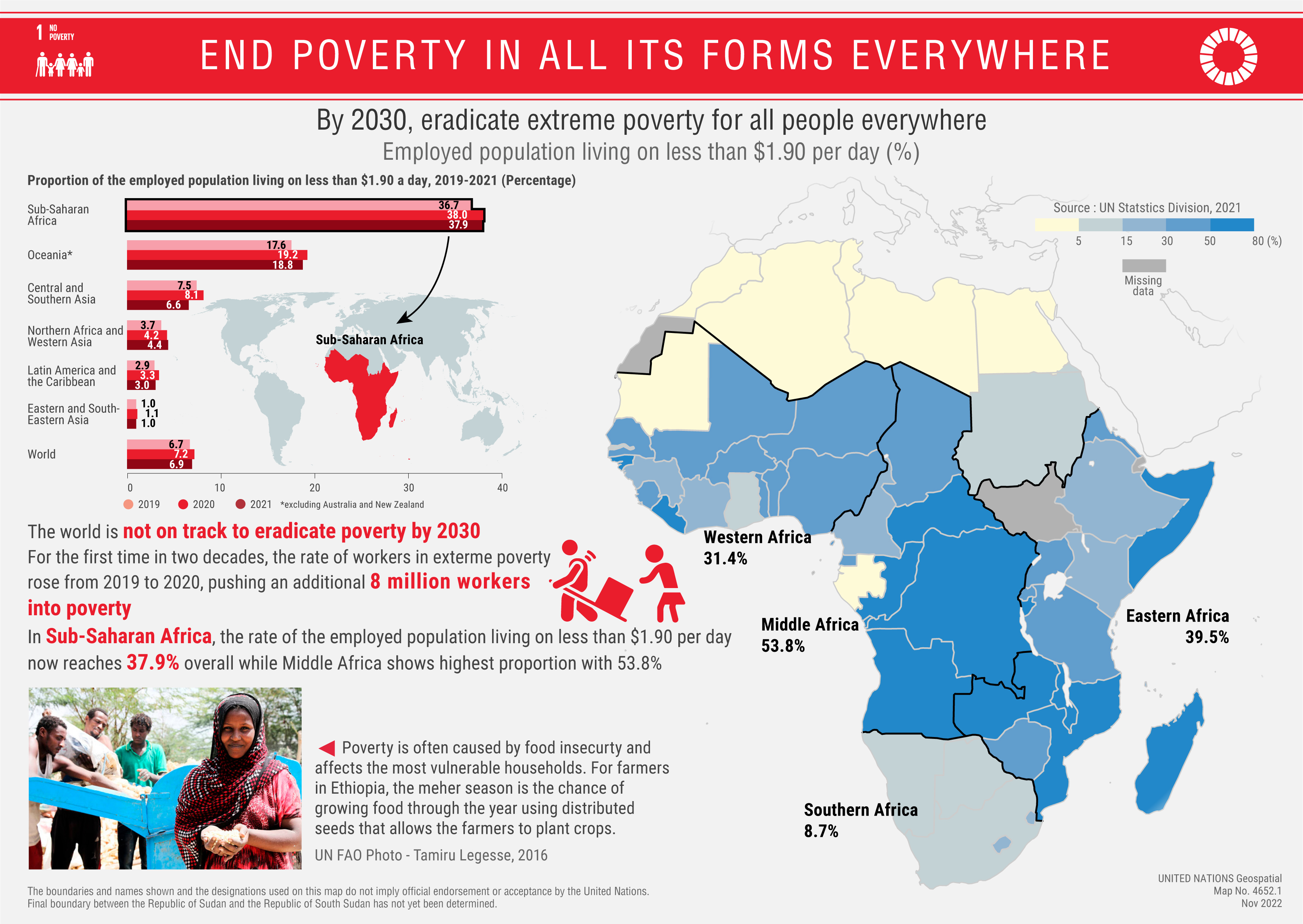
 Map on SDG 01 No Poverty
 -
 International Snakebite awareness day is 19 September
 -
 Spatial analysis and visualization of human rights violations can support strengthening promotion and protection of human rights
 -
 - with Map of Women in National parliament (2000-2022)") Celebrating Women Day (8 March 2023) - with Map of Women in National parliament (2000-2022)
Celebrating Women Day (8 March 2023) - with Map of Women in National parliament (2000-2022) -
 Map on SDG17 Partnerships
 -
 Map on SDG16 Peace, Justice and Strong Institutions
 -
 Map on SDG15 Life On Land
 -
 Map on SDG14 Life Below Water
 -
 Map on SDG13 Climate Action
 -
 Map on SDG12 Responsible Consumption and Production
 -
 Map on SDG11 Sustainable Cities and Communities
 -
 Map on SDG10 Reduced Inequalities
 -
 Map on SDG09 Industry, Innovation and Infrastructure
 -
 Map on SDG08 Decent Work and Economic Growth
 -
 Map on SDG07 Affordable and Clean Energy
 -
 Map on SDG06 Clean Water and Sanitation
 -
 Map on SDG05 Gender Equality
 -
 Map on SDG04 Quality Education
 -
 Map on SDG03 Healthy Lives
 -
 Map on SDG 02 Zero Hunger
 -
 Map on SDG 01 No Poverty
 -
 Map on SDG 01 No Poverty
 -
 Map on SDG 01 No Poverty
 -
 To mark GIS day on 17 November, a map on each SDG will be published for subsequent 17 days
 -
 Satellite image of Gaza on 20 May 2021 as UN Secretary-General welcomes Gaza ceasefire announcement between Israel and Hamas
 -
 Marking International Mother Earth Day with the Amazon rainforest, crucial to regulate global warming
 -
 Member States increasing their commitment of Paris Agreement to achieve Net Zero Emissions
 -
 Ninth session of the UN Committee of Expert on Global Geospatial Information Management (UN-GGIM)
 -
 Hunger Map prepared by the World Food Programme
 -
 Former Secretary-General explores the map of the Blue Line
 -
 Jordan briefing the Security Council with maps
 -
 Map of the World showing dependent territories
 -
 Former Secretary-General reviews the map detailing deployment location of UNEF
 -
 Celebrating International Women's Day 2021 and the global effort for increased representation of Women
 -
 Mapping flood damage to crops using drones in Malawi
 -
 Global map of Women in Politics
 -
 Peacekeepers consult map to navigate through Western Sahara
 -
 Damage analysis uses satellite imagery after an earthquake hits Haiti
 -
 Satellite images show the degradation to our environment
 -
 Security Council exhibits maps and photographs during the crisis in the Caribbean
 -
Celebrating International Women's Day 2021 and the global effort for increased representation of Women 1
-
") False Colour Composite of ALOS-PALSAR image over one area of Darfur
False Colour Composite of ALOS-PALSAR image over one area of Darfur -
 consult a map. UN Photo/Grebien, 2011.") Peace Operations consult map during patrol in the Golan Heights
Peace Operations consult map during patrol in the Golan Heights -
 Earth observation plays a critical role to evaluate, monitor and assess disasters impact and deliver Humanitarian aid
 -
 Tactical analysis of the attack over Mosul by the Iraq Special Forces against the Islamic State
 -
 Location information is a foundation of elections and in understanding election results and the political landscape of a country
 -
 Pollution index analysis is used in Peace Operations to reduce environmental impact to contribute to “Greening the Blue”
 -
 Capacity building and training on the use of Global Positioning System
 -
 Imagery and analysis enable to monitor and assess disaster impact to infrastructure
 -
 Public health is the first use of geospatial information to analyze and understand the spread of diseases
 -
 Cartography helps visualize and monitor Sustainable Development Goals
 -
 Satellite imagery used for assessment and aid relief efforts after earthquake hit Port-Au-Prince
 -
 Panel of Experts uses earth observation to assess and monitor facilities at Yongbyon, Democratic People's Republic of Korea
 -
 in Goma (2013). UN Photo/Liechti") Peace operations launch first UAV programme in the Democratic Republic of the Congo
Peace operations launch first UAV programme in the Democratic Republic of the Congo -
 Earth observation to evaluate natural risk to human settlements and agriculture in the east of the Democratic Republic of the Congo
 -
 Sanctions Committee uses earth observation to document the presence of military aircrafts in airport in South Sudan
 -
 Documenting damages by air strike on civilian residential area in Ṣanʿā
 -
 Analyses of imagery shows alleged intentional burnt field in Yambio province
 -
 Analyses of satellite data showed that the Arctic ice cap shrank to the second-lowest minimum on record
 -
 Using drones in peace operations
 -
 shows the city of Bujumbura during the Operation des Nations Unies au Burundi (ONUB).") Sub-meter imagery of Burundi
Sub-meter imagery of Burundi -
 Landsat images of Marshlands in Iraq
 -
 Aerial image from the War in Korea
 -
 Surveying the Blue line
 -
. UN Geospatial, 1993") Boundary pillar survey and construction
Boundary pillar survey and construction -
 Iraq-Kuwait boundary survey network
 -
 Technical programmes in Afghanistan
 -
 Covid-19 dashboard
 -
 Database-driven maps and analysis overlay
 -
 First map made with computer in the United Nations
 -
 Hand-made map of Bolivia
 -
 Map 168, Woman Suffrage - 11 November 1918
 -
 Map 169, Woman Suffrage - 14 August 1945
 -
 Map 170, Woman Suffrage - 1 June 1949
 -
 Map 296, August 1950: Itinerary of the United Nations Visiting Mission to Trust Territories in the Pacific
 -
 Map No. 337 June 1951: Peru: Sketch map of Cusco Region
 -
 Map No. 341, August 1951: Trust Territory of Tanganika
 -
 Map No. 946, August 1957: Trust Territories
 -
 Map No. 1274, August 1960: Deployment of units of the United Nations Force as of 19 August 1960
 -
 Map No. 2930, November 1977: UNFICYP
 -
 Map No. 3306, October 1984: Anguilla profile map
 -
 Map No. 3612, January 1991: Operation Desert Storm
 -
 Map No. 3841, July 1994: Newly Independent States of the Former USSR
 -
 Map No. 3887 Rev.1, June 1995: UNMOT
 -
 Map No. 4136 Rev.1 August 2001: The World Today
 -
 Map No. 47, May 1947: Palestine
 -
 Map No. 2916, November 1976: UNDOF
 -
Security Council exhibits maps and photographs during the crisis in the Caribbean 1
-
 UNDP provides assistance to Land Survey Programme for “Farming for Development” 1
 -
Satellite images show the degradation to our environment 1
-
Damage analysis uses satellite imagery after an earthquake hits Haiti 1
-
Peacekeepers consult map to navigate through Western Sahara 1
-
Global map of Women in Politics 1
-
Mapping flood damage to crops using drones in Malawi 1
-
 Evidence-based geospatial information and technology enables to observe and monitor changes to fragile sea and land ecosystems
 -
Former Secretary-General reviews the map detailing deployment location of UNEF 1
-
Map of the World showing dependent territories 1
-
Jordan briefing the Security Council with maps 1
-
Former Secretary-General explores the map of the Blue Line 1
-
Hunger Map prepared by the World Food Programme 1
-
Ninth session of the UN Committee of Expert on Global Geospatial Information Management (UN-GGIM) 1
-
 Map 2 of the United Nations
 -
 UN Map Library in 1954
 -
 Briefing the Security Council with maps
 -
 in 2009") SG Ban Ki-moon reviews map
SG Ban Ki-moon reviews map -
 Peacekeepers navigate using GI and Maps
Experts from Member States

Committees and groups of experts have been established in the United Nations as intergovernmental mechanisms to consider how geography and geospatial information can address global challenges and set directions, policies, norms and methods in this domain
Secretariat

Offices and departments of the Secretariat use geospatial information in the context of the delivery of their mandates, including through satellite imagery analysis, advanced analytics, geodata management, geovisualization and web-solutions.
Security Council
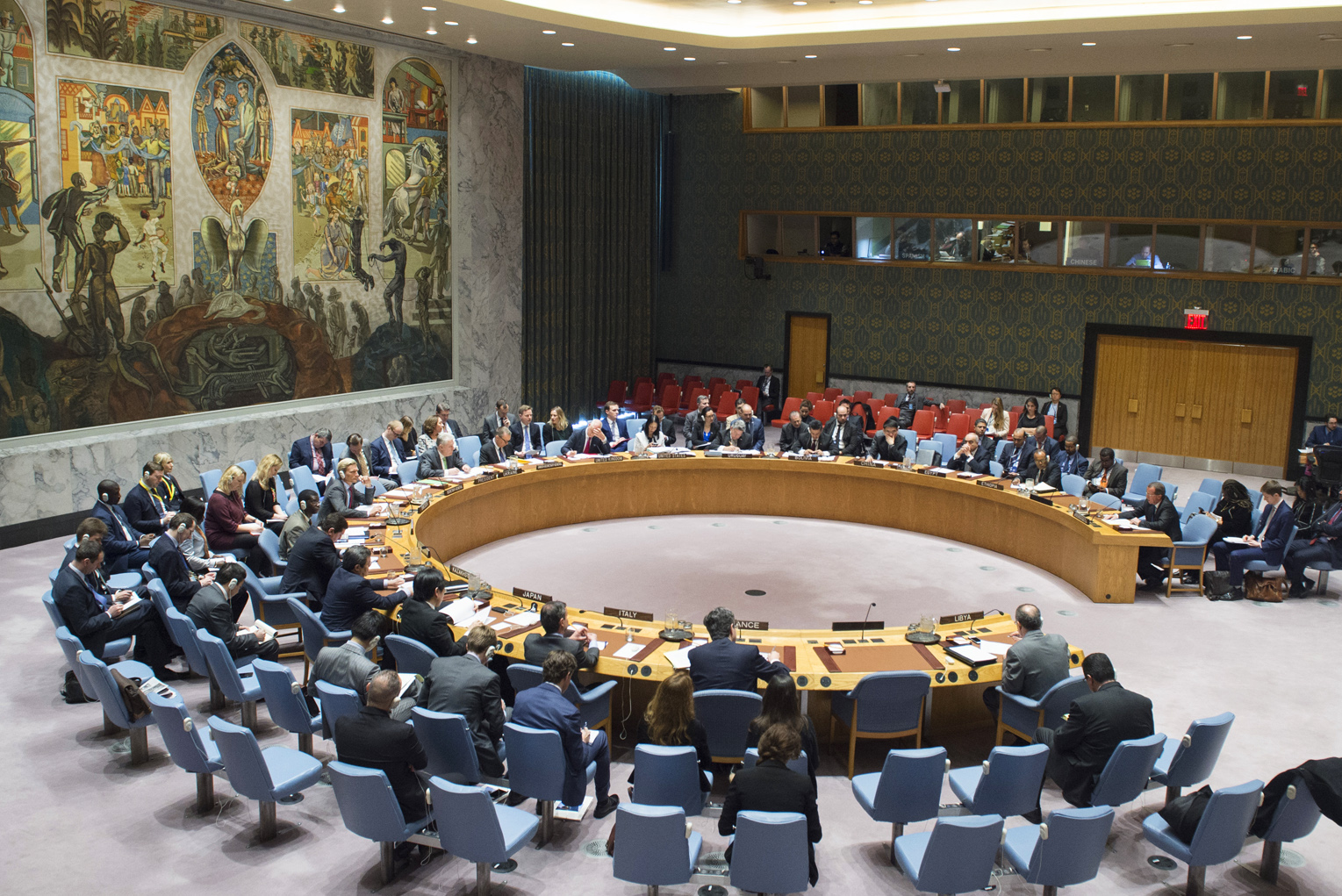
The Security Council has primary responsibility for the maintenance of international peace and security. Geospatial information informs consultations, discussions and proceedings of the Security Council and supports Sanctions Committees and Panels of Experts.
Specialized Agencies
The United Nations System works toward the availability of coordinated geospatial information and services for effective support to Member States, United Nations operations and mandates on local, national, regional and global challenges, including the Sustainable Development Goals.
Leadership
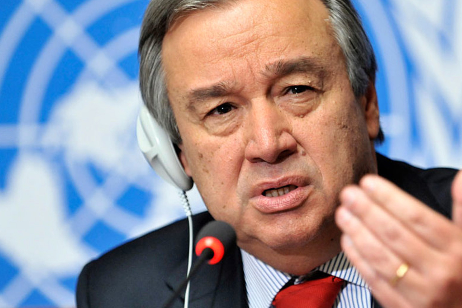
The Secretary-General of the United Nations uses geospatial information for decision-making, day-to-day operations, situational awareness, monitoring of global trends and in the context of the peaceful resolution of conflict between countries.
General Public

The Organization aims to avail documents and materials free of charge, including geospatial information and cartographic publications, to Member States, the international community, scholars and the public at large.